Ecologist and simulation modeller

FOR-CAST Research & Analytics

Biography

Dr. Chubaty is an ecologist, simulation modeller, and co-developer of the open source SpaDES simulation platform. He completed his PhD at Simon Fraser University modelling host selection in mountain pine beetle (MPB), and postdoctoral research at Université Laval and Natural Resources Canada developing forecasting models of MPB spread.

He currently operates FOR-CAST Research & Analytics in Calgary, Canada, which supports the development and integration of models simulating forest vegetation dynamics, wildfire, insect disturbance, and wildlife populations to inform decision making for land management and species at risk. He is an advocate for open source, open data, and reproducible workflows.

Interests

  • insect outbreaks
  • forest ecology
  • cumulative effects
  • simulation modelling

Education

  • PhD in Biological Sciences, 2014

    Simon Fraser University

  • BSc in Biological Sciences, 2005

    University of Calgary

Projects

*

Habitat Connectivity

We have reimplemented and updated the grainscape R package for landscape connectivity, habitat, and protected area network analyses.

SpaDES: Spatial Discrete Event Simulation

A collection of R packages for implementing a variety of event-based models, with a focus on spatially explicit models.

Boreal forest ecosystem forecasts

We are integrating various simulation models dealing with forest vegetation dynamics, fire, insect disturbance, and wildlife populations, to inform decision making in these management areas.

LandWeb: historic range of variation in western boreal forests

LandWeb is the first large scale, data-driven approach to simulating historic natural ranges of variation (H/NRV). This model integrates two well-used models for forest stand succession and fire simulation, and is implemented using the SpaDES platform.

Simulating mountain pine beetle eastward spread

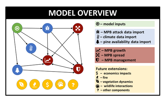
The continued eastward spread of mountain pine beetle (Dendroctonus ponderosae Hopk.; MPB) now threatens the boreal forests of eastern Alberta, Saskatchewan, and beyond. Predicting the outbreak and spread dynamics of this insect in jack pine, and to evaluate control measures to mitigate a potentially devastating loss of forest habitat and timber supply requires not only a complex understanding of the various inputs to this system and their interactions (e.g., MPB population dynamics, climate impacts, landscape features) but also the technical capacity to run large-scale spatial simulation models, and to update them quickly as new data are acquired and new models are developed. …

Recent Publications

Quickly discover relevant content by filtering publications.

Climate-sensitive forecasts of marked short-term and long-term changes in the distributions or abundances of Northwestern boreal landbirds

Climate change presents a major threat to biodiversity globally. Northern ecosystems, such as Canada’s boreal forest, are …

Will this umbrella leak? A caribou umbrella index for boreal landbird conservation

Conservation approaches that efficiently protect multiple values, such as the umbrella species concept, have been widely promoted with …

Climate-informed forecasts reveal dramatic local habitat shifts and population uncertainty for northern boreal caribou

Most research on boreal populations of woodland caribou (Rangifer tarandus caribou) has been conducted in areas of high anthropogenic …

Recent & Upcoming Talks

Cumulative effects research in SpaDES

Natural resource management decisions benefit from cumulative effects research that efficiently integrates scientific knowledge across …

Data to decisions: a multispecies approach case study for Northwest Territories

Predicting caribou resource selection and demography under landscape and climate change

Facing the tree-slayer: forecasting Mountain Pine Beetle spatial spread in SpaDES

Software

Author

  • fpCompare: Reliable comparison of floating point numbers. CRAN; GitHub; Website
  • grainscape: Efficient modelling of landscape connectivity, habitat, and protected area networks. CRAN; GitHub; Website
  • LandR: Landscape Ecosystem Modelling in R. GitHub; Website
  • LandWebUtils: Additional utilities for LandWeb analyses. GitHub; Website
  • map: Defines a meta class of geographical objects, the ‘map’ class, and associated tools. GitHub; Website
  • NetLogoR: A Port of ‘NetLogo’ Functions and Language to R. CRAN; GitHub; Website
  • pemisc: Miscellaneous utilities developed by the Predictive Ecology Lab Group. GitHub; Website
  • quickPlot: Develop and run spatially explicit discrete event simulation models. CRAN; GitHub; Website
  • reproducible: Develop and run spatially explicit discrete event simulation models. CRAN; GitHub; Website
  • SpaDES: Develop and run spatially explicit discrete event simulation models. CRAN; GitHub; Website
  • SpaDES.addins: Tools and RStudio addins for ‘SpaDES’ and ‘SpaDES’ module development. CRAN; GitHub; Website
  • SpaDES.core: Core functionality for Spatial Discrete Event Simulation (SpaDES). CRAN; GitHub; Website
  • SpaDES.experiment: Simulation experiments within the SpaDES ecosystem. GitHub; Website
  • SpaDES.shiny: Utilities for building shiny-based apps for SpaDES simulations. GitHub; Website
  • SpaDES.tools: Additional modelling tools for Spatial Discrete Event Simulation (SpaDES) module development. CRAN; GitHub; Website

Contributor

  • miniCRAN: Create a mini version of CRAN containing only selected packages. CRAN; GitHub